This week, we were able to gain access to an official USGS map and analyze its contents.
Here's some data I was able to obtain from looking at this map:
Beverly Hills Quadrangle - 7.5 Minute Series
- The quadrangles that are adjacent to this one are: Canoga Park, Van Nuys, Burbank, Topanga, Hollywood, Venice, and Inglewood.
*Missing Quadraangle - (Pacific Ocean)
- This quadrangle was first created in the year, 1966.
- The two datums used to create this map are: North American Datum 27 for Horizontal, and National Geodetic Vertical Datum of 1929 for Vertical.
- The scale of this map is 1:24000, meaning that one unit on the map is equivalent to 24,000 units on the ground.
- 5 centimeters on the map is equivalent to 1200 meters on the ground.
- 5 inches on the map is equivalent to 1.89 miles on the ground.
- 1 miles on the ground is equivalent to 2.64 inches on the map.
- 3 kilometers on the ground is equivalent to 12.5 centimeters on the map.
- The contour interval on the map is 20 feet.
- There are unique coordinates for every location on the map. Here are a few I have been able to calculate in degrees, minutes, and seconds, and also in decimal degrees:
- The Public Affairs Building: (34.074 deg N, 118.440 deg E) or (34 deg, 4'26'' / 118 deg, 26'24'')
- The tip of the Santa Monica Pier: (34.007 deg N, 118.499 deg E) or (34 deg, 0'26'' / 118 deg, 29'55'')
- The Upper Franklin Canyon Res: (34.120 deg N , 118.409 deg E) or (34 deg, 7'13'' / 118 deg, 24'32'')
-Elevations also vary throughout the map, but they don't have to be unique to any specific location. Here are some examples:
- Greystone Mansion: 570 feet or 174.7 meters
- Woodlawn Cemetery: 140 feet or 42.7 meters
- Crestwood Hills Park: 720 feet or 219.5 meters
- The UTM Zone of the map is UTM Zone 11.
- The UTM Coordinates for the lower left corner of the map are: 0361500, 3763000
- Each square in the UTM gridlines contain 1 sq. kilometer or 1000000 sq. meter
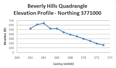
- Here's a graphic of the elevation profile I created when following Northing 3771000 and recording elevations at every intersecting Easting:
- The magnetic declination of the map is shown to be 14 degrees clockwise, which means it has deviated in the positive direction.
- Also, when observing the elevation changes, it can be inferred that the water from the stream located between the 405 Freeway and Stone Canyon Reservoir flows southward since elevation declines as it goes from north to south.
- Interesting enough, UCLA's campus is located within the Beverly Hills' Quadrangle:
All this information, just from one map!
-Sal


No comments:
Post a Comment